
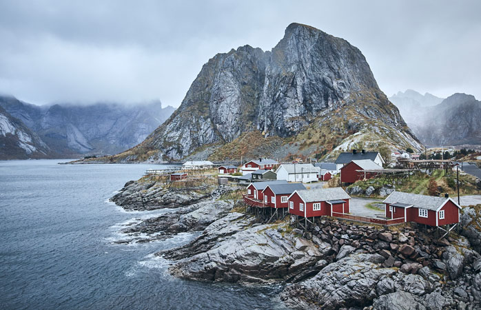
Norway’s Lofoten Islands
Located above the Arctic Circle and commonly referred to as Lofoten, the Lofoten Islands are scattered over the turbulent waters of the Norwegian Sea on the west coast of Norway. Conditions on the Norwegian islands are harsh, but visitors come here for the extraordinary nature: sheer mountains, pristine beaches, world-famous surf waves and, of course, Norway’s symbol fjords. Lofoten forms a canal in mainland Norway, the best known city nearby is Tromsø. Just like Tromsø, Lofoten is an ideal winter vacation spot to watch the Northern Lights (Aurora Borealis). Thanks to the nature of the region that offers many different possibilities, you can go hiking, skiing, fishing and even scuba diving.
There is no bad weather, just the wrong clothes.
How to get to the Lofoten Islands?
Despite its distance, Lofoten is not difficult to reach. You can reach the village of Evenes with a short flight from Oslo and pick up your rental car from there. Even in October, your vehicle’s tires will likely be studded, as the roads are often icy and the weather is constantly changing. Driving can be boring at times, but the 3-hour trip from Evenes to Sennesvik, the first stop of the trip, is nothing short of boring.

Due to the warm water current, Lofoten has a much milder climate than other places at the same latitude. However, if you are visiting the islands during a variable weather period, your car will be more than just a means of transportation.
Finnglunten
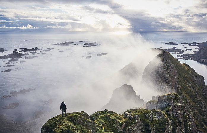
The Lofoten Islands are a paradise for those who love hiking. For curious novices and seasoned professionals alike, there are plenty of hiking trails showcasing the beauty of the wilderness. For beginners or in bad weather, hiking to the vantage point in Finnglunten is a good choice. The trail is made for mountain bikes, but is also suitable for hikers. In return for your hard work, you will arrive at a hill where you can see 360° panoramic views of the surrounding mountains and fjords.
Top tip: You can use your time faster by renting a mountain bike.

It takes about three or four hours to get up and down Finnglunten and take pictures in the meantime. It goes without saying that you need to drink plenty of fluids while walking. Then how about a coffee with the view?
Senja and Segla
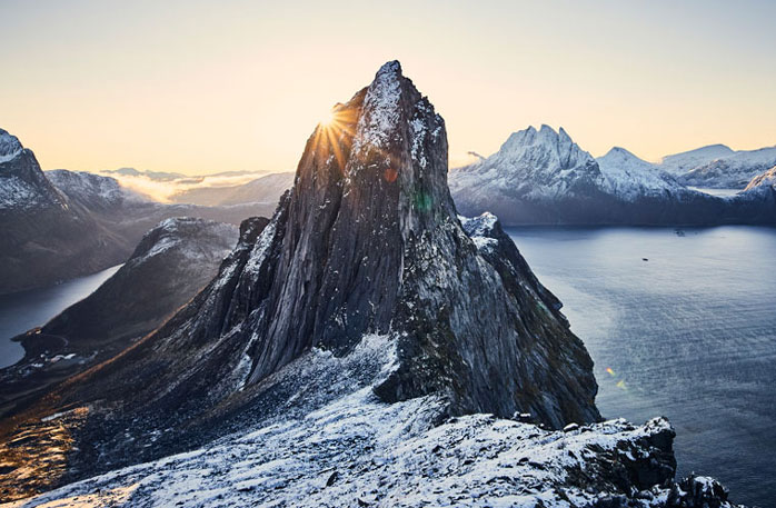
Senja is a large island between the canal Lofoten and the city of Tromsø. Although not technically a part of Lofoten, Senja is just as beautiful as Lofoten. One of its most famous spots is the mountain known as Segla or Senja Sail. You can go up to Segla’s vantage point on a path suitable for hikers of all levels. However, if you somehow take a wrong turn, the same path will take you to the top of Segla. “Easy hiking suitable for families” can turn into a steep and strenuous rock climbing…
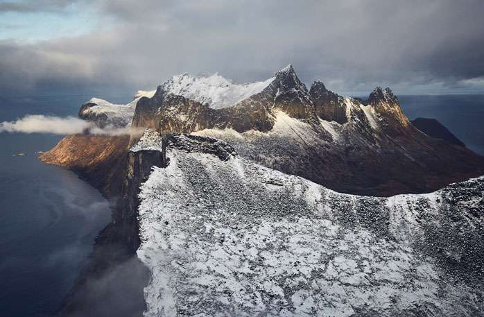
…But it’s totally worth it. If the first snow of the year has started to fall, the view at the summit is simply breathtaking.
Top tip: You must be prepared for rock climbing and you need to have some rock climbing tools for that.
Northern Lights
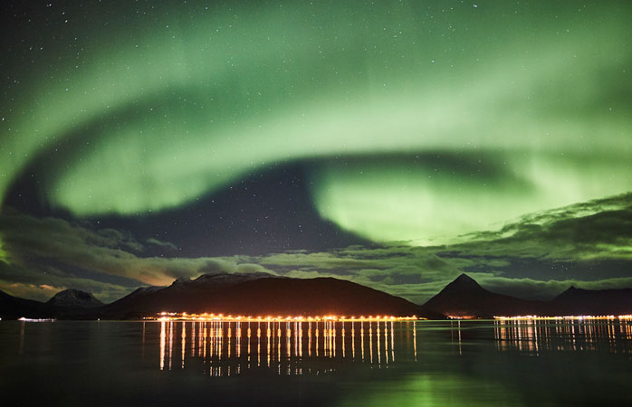
To have the chance to see the Northern Lights, you should visit Lofoten between September and April. These variable lights in the sky, also known as the Aurora Borealis, are caused by electrically charged particles from the sun reaching the earth’s magnetic field. The poles are where the magnetic field is weakest, so the further north you go, the better your chances of seeing the lights. Lofoten is the perfect place for that.
Those who watch the otherworldly dance of the Northern Lights under the star-studded sky of the Arctic Region witness one of nature’s most magnificent light shows, an extraordinary natural phenomenon.
Top tip: Get a set of information on how to photograph the northern lights to perpetuate that memory.
Ryten and Kvalvika
Slightly more experienced hikers must follow the popular trail that leads to the Ryten viewpoint. This hill is considered one of the most accessible, although it’s a five-hour hike that gets pretty steep at some points. During the walk, you will encounter wonderful views. Kvalvika, which is similar to the tropical beaches you see when you reach the top, is so fascinating that it is almost impossible to take a photo properly. It is not difficult to understand why this road is one of the most popular routes in Lofoten.
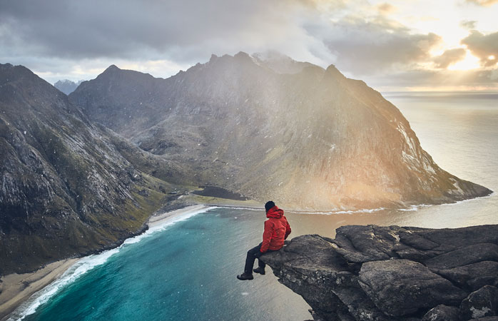
Another reason why the route is so popular is the photogenic rock outcrop at the end of the road. This ledge looks like it’s only for the fearless traveler, but of course it’s not as dangerous as it looks because there’s safe ground just below.

